Yep, it's that time again. Nearing fall.
So, as the westerlies once again migrate southward, and entangle with what remains of instability from the summer, the fall season initiates. Some years are blockbusters; other, lacklusters.
This could be the first of such an event. It's Sept... yeah, I know. Climatology doesn't favor it. But it's still worth watching. An rather large polar vortex, strong for this early in the year, is situated in Hudson Bay. Such a vortex often flattens out as the Pacific jet stream asserts itself and knocks it out. Positive height anomalies are situated in the Mongolia area attm. (ref: http://www.meteo.psu.edu/%7Egadomski/HEMI500/5dayloopjap.html )
There is actually some support for a trough over the western US in about 10 days or so. Key is the subtropical ridge. Is it strong enough to stop the trough from amplifying? Will the Pacific jet be strong enough to amplify the trough progressively, or will it cut off? Ah... so many questions and so few answers; I can feel the spirit of severe rushing back within me. Enough of excessive verbage. My point is... there is something worth watching in about 10 days for a possible severe wx threat.
Tuesday, September 11, 2007

Wednesday, July 25, 2007
Regarding last post
Apparently, I just realized that the velocity potential/upper divergence/MJO map I posted was from July 2006. Weird, but it's only my fault that I did not take a closer look at the datestamp discrepency.
The correct map is here:

The enhacement areas are leaving the Atlantic basin right now at an initial glance, but a new burst as appeared in the eastern Pacific. Given current satellite trends, I suspect that will intensify and move eastward. When that is leaving (maybe in about a 4 days to a week), we could see some marginal quick development. But since the Azores High is in its strongest state right now, and due to strong shearing winds in the GOM, I don't foresee any major development.
Phew! What a flip-flop.
The correct map is here:

The enhacement areas are leaving the Atlantic basin right now at an initial glance, but a new burst as appeared in the eastern Pacific. Given current satellite trends, I suspect that will intensify and move eastward. When that is leaving (maybe in about a 4 days to a week), we could see some marginal quick development. But since the Azores High is in its strongest state right now, and due to strong shearing winds in the GOM, I don't foresee any major development.
Phew! What a flip-flop.
Musings on the Atlantic Hurricane Season
Key issues in this post: possible development in the next week-two weeks; effects of the negative SST anomalies in the eastern Atlantic; hot spots for landfall activity through the remainder of the season.
So far, the Atlantic has been quiet. Not abnormally quiet as it has been in the Pacific (both the west and the east), but quiet, as usually is during this time of year. I expect this to change.
Here are the current velocity potential anomalies:

Green areas indicate enhanced divergence and increased thunderstorm activity. This area of enhancement has actually stalled the past few days, likely due to what I'll explain later in this post. In fact it was about to bipass the Atlantic until TS Dalila in the EPAC, along with a divergence from strong anticyclone in the Four Corners region, reinvigorated the ITCZ in the area. Still, the signal is rather weak, continuing to be hurt by a strong Azores High in the Atlantic, and negative SST anomalies due to the developing La Nina in the EPAC.
The question now is: will the enhanced areas of divergence enter the Atlantic. What I've noticed is that tropical cyclone development usually occurs when the enhancement areas are leaving. The Azores High tends to peak in strength in late July, so it will likely weaken from here on out. In fact, a weak trough is forecasted to amplify near the Azores, which will certainly dent the high pressure cell across the area, temporarily halting the upwelling and the SAL intrusions. When the Azores High weakens, the ITCZ will start moving northward, and perhaps by that time, the areas of enhanced divergence can get settled in the eastern Atlantic.
Don't get me wrong - the CV area doesn't look healthy - it will take time for one month of upwelling to evaporate away, even with strong sun. But that does mean, with the enhancement areas leaving the western Atlantic, we could see some development in the central or western Atlantic in about two weeks. Confidence is low, however. At this point, East coast troughiness says that Texas to Central America are the main threats if something homegrown develops, or it will come close to the east coast or recurve if something develops further east.
This discussion now brings up the second point. As of right now, the Azores High has done a number on upwelling in the eastern Atlantic. This is the first time in a long time that such negative anomalies have appeared in the MDR. Given that the Azores High does weaken like it is forecasted to, the eastern Atlantic may recover in about 2-3 weeks, which indicates possible CV development later in August. But if the Azores High remains strong, and the cold pool remains there, CV storms are not likely going to form. While the current cold pool suggests CV season might start a bit later, it is uncertain what effect, if any, it will have with the number of CV storms. If the Azores High weakens in September, and the CV storms finally come rolling, they will more likely recurve.
Which brings up the third point. Where are the biggest threats for hurricanes this year? La Nina climo argues for stronger Caribbean storms. The East Coast trough will probably remain through much of the year, if so, the East Coast would be under the gun and the Gulf Coast might get a reprieve.
For now, I would say that Mexico, Central America, Hispaniola, and Cuba are under a relatively high threat, and that Texas, Puerto Rico, and the Lesser Antilles have a moderate threat (maybe a lower threat for S. America, ABC Islands and the southernmost Lesser Antilles). All of Florida and the east coast, along with Bermuda, I would say, has a moderate threat, and the Gulf Coast has a low threat. But that's just my prediction.
So far, the Atlantic has been quiet. Not abnormally quiet as it has been in the Pacific (both the west and the east), but quiet, as usually is during this time of year. I expect this to change.
Here are the current velocity potential anomalies:
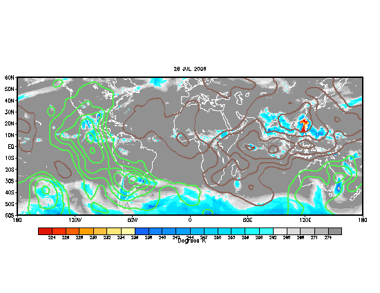
Green areas indicate enhanced divergence and increased thunderstorm activity. This area of enhancement has actually stalled the past few days, likely due to what I'll explain later in this post. In fact it was about to bipass the Atlantic until TS Dalila in the EPAC, along with a divergence from strong anticyclone in the Four Corners region, reinvigorated the ITCZ in the area. Still, the signal is rather weak, continuing to be hurt by a strong Azores High in the Atlantic, and negative SST anomalies due to the developing La Nina in the EPAC.
The question now is: will the enhanced areas of divergence enter the Atlantic. What I've noticed is that tropical cyclone development usually occurs when the enhancement areas are leaving. The Azores High tends to peak in strength in late July, so it will likely weaken from here on out. In fact, a weak trough is forecasted to amplify near the Azores, which will certainly dent the high pressure cell across the area, temporarily halting the upwelling and the SAL intrusions. When the Azores High weakens, the ITCZ will start moving northward, and perhaps by that time, the areas of enhanced divergence can get settled in the eastern Atlantic.
Don't get me wrong - the CV area doesn't look healthy - it will take time for one month of upwelling to evaporate away, even with strong sun. But that does mean, with the enhancement areas leaving the western Atlantic, we could see some development in the central or western Atlantic in about two weeks. Confidence is low, however. At this point, East coast troughiness says that Texas to Central America are the main threats if something homegrown develops, or it will come close to the east coast or recurve if something develops further east.
This discussion now brings up the second point. As of right now, the Azores High has done a number on upwelling in the eastern Atlantic. This is the first time in a long time that such negative anomalies have appeared in the MDR. Given that the Azores High does weaken like it is forecasted to, the eastern Atlantic may recover in about 2-3 weeks, which indicates possible CV development later in August. But if the Azores High remains strong, and the cold pool remains there, CV storms are not likely going to form. While the current cold pool suggests CV season might start a bit later, it is uncertain what effect, if any, it will have with the number of CV storms. If the Azores High weakens in September, and the CV storms finally come rolling, they will more likely recurve.
Which brings up the third point. Where are the biggest threats for hurricanes this year? La Nina climo argues for stronger Caribbean storms. The East Coast trough will probably remain through much of the year, if so, the East Coast would be under the gun and the Gulf Coast might get a reprieve.
For now, I would say that Mexico, Central America, Hispaniola, and Cuba are under a relatively high threat, and that Texas, Puerto Rico, and the Lesser Antilles have a moderate threat (maybe a lower threat for S. America, ABC Islands and the southernmost Lesser Antilles). All of Florida and the east coast, along with Bermuda, I would say, has a moderate threat, and the Gulf Coast has a low threat. But that's just my prediction.
Wednesday, July 4, 2007
2007 Tornado Season: A Review (FEB-JUN)
The 2007 tornado season was a fantastic one for chasers who went early. Synoptically evident event after event. Although the mesoscale often went awry (you can't predict that stuff from way out), most chasers from March-early May were treated with many good events. But then came the "Death Ridge". There were still events in late May, and June, but they were not as numerous, and often came down to the mesoscale. Of course though, my general rule of thumb is that more things will go wrong with the mesoscale, in a given length of time, than will go right. Although two events pop out in my mind, when nearly everything went right (March 28 and April 21), there were numerous other events which everything went wrong. Nevertheless, the synoptic events are listed below:
Feb. 23-24 (Early season tornadoes in TX, Lower Miss. R. Valley tornadoes)
Feb. 28 - Mar. 1 (Early season EF4 in KS, SE Enterprise, AL Tornado outbreak)
March 28 (High Plains tornado outbreak)
April 13-14 (Mainly bust, few tornadoes in TX and Atl Coastal Plain)
April 21 (TX Panhandle tornado outbreak)
April 23-24 (Plains tornadoes, mainly bust, but Eagle Pass, TX tornado included)
May 4-5 (Greensburg tornadoes, tornado outbreak)
June 6-7 (Mainly bust, few tornadoes in WI)
Chasers also caught tornadoes on March 21, May 22-23, and then June 23 in Canada. But otherwise, that was it. However, March 28, April 21, April 23-24, and May 4-5 were epic days for chasers, with many bagging multiple tornadoes, some wedges (exception of last one with Apr 23-24). For many it was a nice reprieve of the relatively boring years of 2005-2006, although certainly not legendary like 2004, 1991, 1993, 1995, 1999 et al (that I would like to correct from my previous post).
For myself, it was a new beginning. This year was the first which I had even attempted long-range severe wx forecasts. They were quite experimental, and I really did not know what to expect. And I did fairly well. Not bragging, but for my first year at attempting this, I felt like I had grabbed onto something that was right.
My high points:
-Seeing the Feb. 23 event several weeks in advance, though I was a little early with the timing
-Seeing that April would be an active month (that was true b/c the pattern was active, even though due to mesoscale factors, the tornado count was around average)
-Correctly forecasting the early June event and the subsequent arrival of the Death Ridge
My low points:
-Seeing the March 28 outbreak from several weeks out, then rescinding my prediction, only to have it happen
-Thinking early April was going to be extremely active (turns out there was a break from April 3-12)
-Not updating the blog as much as I should've
I guess my overall grade for this year's predictions would be a B+. Long-range, that is. Could've been better w/ more updates, and maybe it was luck that helped me, so an A will never be a grade until I've done this for at least 2 or 3 years.
As it is July already, my focus will now shift toward the tropics. With the tropics, I have yet to do a significant amount of research, but I will try my best.
(P.S. Since this only includes Feb thru Jun, my horrible January forecasts do not count. This is not to vindicate myself; rather, there was not enough tornadic activity in January to justify it as part of the 2007 'tornado season'.)
Feb. 23-24 (Early season tornadoes in TX, Lower Miss. R. Valley tornadoes)
Feb. 28 - Mar. 1 (Early season EF4 in KS, SE Enterprise, AL Tornado outbreak)
March 28 (High Plains tornado outbreak)
April 13-14 (Mainly bust, few tornadoes in TX and Atl Coastal Plain)
April 21 (TX Panhandle tornado outbreak)
April 23-24 (Plains tornadoes, mainly bust, but Eagle Pass, TX tornado included)
May 4-5 (Greensburg tornadoes, tornado outbreak)
June 6-7 (Mainly bust, few tornadoes in WI)
Chasers also caught tornadoes on March 21, May 22-23, and then June 23 in Canada. But otherwise, that was it. However, March 28, April 21, April 23-24, and May 4-5 were epic days for chasers, with many bagging multiple tornadoes, some wedges (exception of last one with Apr 23-24). For many it was a nice reprieve of the relatively boring years of 2005-2006, although certainly not legendary like 2004, 1991, 1993, 1995, 1999 et al (that I would like to correct from my previous post).
For myself, it was a new beginning. This year was the first which I had even attempted long-range severe wx forecasts. They were quite experimental, and I really did not know what to expect. And I did fairly well. Not bragging, but for my first year at attempting this, I felt like I had grabbed onto something that was right.
My high points:
-Seeing the Feb. 23 event several weeks in advance, though I was a little early with the timing
-Seeing that April would be an active month (that was true b/c the pattern was active, even though due to mesoscale factors, the tornado count was around average)
-Correctly forecasting the early June event and the subsequent arrival of the Death Ridge
My low points:
-Seeing the March 28 outbreak from several weeks out, then rescinding my prediction, only to have it happen
-Thinking early April was going to be extremely active (turns out there was a break from April 3-12)
-Not updating the blog as much as I should've
I guess my overall grade for this year's predictions would be a B+. Long-range, that is. Could've been better w/ more updates, and maybe it was luck that helped me, so an A will never be a grade until I've done this for at least 2 or 3 years.
As it is July already, my focus will now shift toward the tropics. With the tropics, I have yet to do a significant amount of research, but I will try my best.
(P.S. Since this only includes Feb thru Jun, my horrible January forecasts do not count. This is not to vindicate myself; rather, there was not enough tornadic activity in January to justify it as part of the 2007 'tornado season'.)
Friday, May 18, 2007
The second half of "tornado season" - what will it bring?
Since the outbreak of May 4-6, it has been very quiet. The major polar vortex centers have shifted toward the Atlantic and Europe, leaving positive anomalies over the U.S. and a lackluster Pacific jet. This will likely change. I have been harping on renewed activity late this month, but that is most likely not happening on a grand scale. However a disturbance from the Pacific will dive into the CONUS and provide severe chances for the northern Plains for the next few days, with marginal moisture being the major limiting factor for an otherwise nice shortwave trough.
The bigger event should come in June. As the polar vortex centers shift back into the Pacific as Indian Ocean convection is renewed, the Pacific jet should be reasserted. The subtropical jet is still in full force and there has yet to be a full fledged subtropical block, meaning the jet will have a chance to extend into the eastern Pacific and amplify a trough. Obviously, this threat should be further north, most likely encompassing the Central and/or Northern Plains. And once again, just based on the trends this year, the Midwest should not get the brunt of severe. This idea is supported by the GFS ensembles, though the European model continues to show brutal ridging reasserting itself in early June.
As the month continues, the high should strengthen and I'd expect "summer" to truly set in around mid-June. Early June activity, IMO, will be the last gasp of Tornado Season 2007, which will go down in infamy as the biggest season in the Plains in 8 years, and comparable to the infamous seasons of 1995, 1993, and 1977. The reason for this is based on trends and the fact that the Pacific jet and Alaska vortex becomes a weaker factor closer to summer, compared to the building subtropical high.
The bigger event should come in June. As the polar vortex centers shift back into the Pacific as Indian Ocean convection is renewed, the Pacific jet should be reasserted. The subtropical jet is still in full force and there has yet to be a full fledged subtropical block, meaning the jet will have a chance to extend into the eastern Pacific and amplify a trough. Obviously, this threat should be further north, most likely encompassing the Central and/or Northern Plains. And once again, just based on the trends this year, the Midwest should not get the brunt of severe. This idea is supported by the GFS ensembles, though the European model continues to show brutal ridging reasserting itself in early June.
As the month continues, the high should strengthen and I'd expect "summer" to truly set in around mid-June. Early June activity, IMO, will be the last gasp of Tornado Season 2007, which will go down in infamy as the biggest season in the Plains in 8 years, and comparable to the infamous seasons of 1995, 1993, and 1977. The reason for this is based on trends and the fact that the Pacific jet and Alaska vortex becomes a weaker factor closer to summer, compared to the building subtropical high.
Friday, April 27, 2007
BIG UPDATE
I haven't had enough time to update this blog. But here are the major severe wx events of April:
April 3 - big severe wx outbreak with a couple of tornadoes.
April 10-11 - small event with two very impressive supercells, one over OK, one over AL.
April 13-14 - really had potential with a high risk over TX on the 13th that did not verify.
April 20-21 - tornadoes over the Plains, specifically, NE and the TX Panhandle.
April 23-24 - started out with several discrete and powerful, but widely isolated, Plains supercells. Ended with a high risk bust just to the east over I-35.
Granted, I didn't post a lot on the last two events. But as one can see, it was an active month for severe wx, although not even close to last year.
The limiting factor for this year so far has been the stagnant pattern over Western Europe and the Atlantic, which has been crunching up a fast Pacific jet. The jet is a result of Indian Ocean convection and the associated IO subtropical jet/Siberia polar jet "phasation" (is that even a word, lol?). At any rate, the flow is not as progressive when it punches into the CONUS, so basically a big bowling ball closed low results as the jet energy is forced to crunch up. These big bowling balls tend to not be prolific tornado producers. Case in point: April 24.
WHY DID APRIL 24 BUST?
For those who don't know, April 24, 2007 was predicted to be potentially one of the biggest outbreaks in the Plains in recent years. A big 500mb low was progged to hit a very moist and unstable airmass (the GFS, for instance, had predicted -10 LI's in central OK about a week out, although it did not verify). Many of the ingredients were there. Dr. Greg Forbes of TWC, Larry Cosgrove, among other very good mets were predicting an outbreak on the scale of the intensity of May 3, 1999. An almost unprecedented Day 3 Moderate risk was hoisted by the Storm Prediction Center.
In the end though, it all went bust, as convection formed too early. But why?
IMO, the reason it busted is mainly because the bowling ball closed low which had already stacked by the time. It is fairly common knowledge that a stacked low tends to be less condusive for severe wx. In this case, the dry line pushed very far east as CAA behind it intensified and the low matured and began to stack. Convergence along the dry line intensified, and coupled with strong upper air support, a line formed early and hard.
I think, that perhaps with less instability in the morning, or with some type of earlier convection to stabilize, this could've still ended up being a notable event. Strong instability fostered big anvils, which stablized things, and the convection developed into a line quickly, preventing moist inflow to areas later.
Still though, one tornadic supercell did form along the dryline later that day, a testament to how much potential this setup really had. A high risk was hoisted for central TX later that afternoon, but it mainly busted with few reports in the area. The lack of juxtaposition between the instability axis, the location of initiation, and the low level shear axis probably prevented from supercells which formed there in the afternoon, from being tornadic.
Ironically, the one strong, classic supercell that formed, formed in northern MX and entered deep south TX near Eagle Pass, TX, killing 10 people, 3 in MX, 7 in TX. It had perhaps one of the most impressive radar signatures I've ever seen, along with a monster supercell in rural northwestern KS the night before.
April 3 - big severe wx outbreak with a couple of tornadoes.
April 10-11 - small event with two very impressive supercells, one over OK, one over AL.
April 13-14 - really had potential with a high risk over TX on the 13th that did not verify.
April 20-21 - tornadoes over the Plains, specifically, NE and the TX Panhandle.
April 23-24 - started out with several discrete and powerful, but widely isolated, Plains supercells. Ended with a high risk bust just to the east over I-35.
Granted, I didn't post a lot on the last two events. But as one can see, it was an active month for severe wx, although not even close to last year.
The limiting factor for this year so far has been the stagnant pattern over Western Europe and the Atlantic, which has been crunching up a fast Pacific jet. The jet is a result of Indian Ocean convection and the associated IO subtropical jet/Siberia polar jet "phasation" (is that even a word, lol?). At any rate, the flow is not as progressive when it punches into the CONUS, so basically a big bowling ball closed low results as the jet energy is forced to crunch up. These big bowling balls tend to not be prolific tornado producers. Case in point: April 24.
WHY DID APRIL 24 BUST?
For those who don't know, April 24, 2007 was predicted to be potentially one of the biggest outbreaks in the Plains in recent years. A big 500mb low was progged to hit a very moist and unstable airmass (the GFS, for instance, had predicted -10 LI's in central OK about a week out, although it did not verify). Many of the ingredients were there. Dr. Greg Forbes of TWC, Larry Cosgrove, among other very good mets were predicting an outbreak on the scale of the intensity of May 3, 1999. An almost unprecedented Day 3 Moderate risk was hoisted by the Storm Prediction Center.
In the end though, it all went bust, as convection formed too early. But why?
IMO, the reason it busted is mainly because the bowling ball closed low which had already stacked by the time. It is fairly common knowledge that a stacked low tends to be less condusive for severe wx. In this case, the dry line pushed very far east as CAA behind it intensified and the low matured and began to stack. Convergence along the dry line intensified, and coupled with strong upper air support, a line formed early and hard.
I think, that perhaps with less instability in the morning, or with some type of earlier convection to stabilize, this could've still ended up being a notable event. Strong instability fostered big anvils, which stablized things, and the convection developed into a line quickly, preventing moist inflow to areas later.
Still though, one tornadic supercell did form along the dryline later that day, a testament to how much potential this setup really had. A high risk was hoisted for central TX later that afternoon, but it mainly busted with few reports in the area. The lack of juxtaposition between the instability axis, the location of initiation, and the low level shear axis probably prevented from supercells which formed there in the afternoon, from being tornadic.
Ironically, the one strong, classic supercell that formed, formed in northern MX and entered deep south TX near Eagle Pass, TX, killing 10 people, 3 in MX, 7 in TX. It had perhaps one of the most impressive radar signatures I've ever seen, along with a monster supercell in rural northwestern KS the night before.
Saturday, April 7, 2007
Long-awaited update: 3 significant events including possibly a massive outbreak to come April 10-17
Sorry I have not updated this; been busy.
Regarding the last event in the previous blog, March 28 there was a big outbreak across the Plains. The second system failed to amplify significantly but spawned a big severe wx outbreak with minimal tornado activity on April 3.
If I had time to post, I would've said that there looked to be potential. Now it looks even more likely. Strong 150 kt Pacific Jet (PJ) is coming in. Reloading with record low temperatures across the east and snow all the way down to TX (in April!). Indeed, powerful polar vortex (PV) is right now parked over the Eastern 2/3 of the country. As the PJ moves in, it will kick the PV out, reasserting it near the North Pole. Pacific air will flood the country as several disturbances within the flow amplify over the Intermountain West.
The first threat looks to be from the 10th to the 11th. This one will be a phase of a piece of the PV and an impulse riding along the Pacific Jet. Right now, a lead disturbance that goes through in the morning is the question mark. Will it be weak enough to not cause too much an effect for the bigger stuff in the afternoon? Nevertheless, given my analysis of previous events, the fact that moisture might be limited will not allow this to be a historic outbreak, IMO.
Next threat: 13th thru 15th. This one could be the biggest depending on the third system (see belwo). Another disturbance will come in via the Pacific Jet Highway. This time there could be more moisture to work with. Details are sketchy right now, since it's a week away, but dynamics look incredible (just as they will for the first system), but there will be more moisture to work with - latest GFS paints 65° to 70°F dewpoints all the way north to Memphis, TN. Caveat may be if the first system doesn't move out quickly enough.
Final threat before I think things calm down again: 15th thru 18th. This one is a question mark. The full force of the PJ rolls in this time, so this certainly has the most potential with regards to dynamics. But the instability is the question mark. It looks like this might be the signal of another pattern change as the Pacific becomes extremely convoluted after this and the NAO tanks. In other words, another cold pattern for the east. (BTW, do want to remind everyone that the idea of the "reloading pattern" with the PV over Hudson Bay -- only works consistently for early season and cold season outbreaks. Not going to go further into that though). If the NAO tanks early, this system will not have moisture to work with as the second system gets caught up and trapped behind the building ridge/block. If the NAO does not tank early, or more specifically, the second system moves out of the way, this might be the biggest of the three events as it will have the full mass of the PJ helping it to amplify into a low-amplitude high-wavelength trough -- most ideal for big outbreaks. Won't get into too much detail here as well.
Most of the major global models that go to the 240 hr range - specifically the GFS, CMC, and EURO, show the progression of these three systems. So confidence is much higher than last time where I had the right idea initially but bombed it due to relying too much on the poor model performance.
Regarding the last event in the previous blog, March 28 there was a big outbreak across the Plains. The second system failed to amplify significantly but spawned a big severe wx outbreak with minimal tornado activity on April 3.
If I had time to post, I would've said that there looked to be potential. Now it looks even more likely. Strong 150 kt Pacific Jet (PJ) is coming in. Reloading with record low temperatures across the east and snow all the way down to TX (in April!). Indeed, powerful polar vortex (PV) is right now parked over the Eastern 2/3 of the country. As the PJ moves in, it will kick the PV out, reasserting it near the North Pole. Pacific air will flood the country as several disturbances within the flow amplify over the Intermountain West.
The first threat looks to be from the 10th to the 11th. This one will be a phase of a piece of the PV and an impulse riding along the Pacific Jet. Right now, a lead disturbance that goes through in the morning is the question mark. Will it be weak enough to not cause too much an effect for the bigger stuff in the afternoon? Nevertheless, given my analysis of previous events, the fact that moisture might be limited will not allow this to be a historic outbreak, IMO.
Next threat: 13th thru 15th. This one could be the biggest depending on the third system (see belwo). Another disturbance will come in via the Pacific Jet Highway. This time there could be more moisture to work with. Details are sketchy right now, since it's a week away, but dynamics look incredible (just as they will for the first system), but there will be more moisture to work with - latest GFS paints 65° to 70°F dewpoints all the way north to Memphis, TN. Caveat may be if the first system doesn't move out quickly enough.
Final threat before I think things calm down again: 15th thru 18th. This one is a question mark. The full force of the PJ rolls in this time, so this certainly has the most potential with regards to dynamics. But the instability is the question mark. It looks like this might be the signal of another pattern change as the Pacific becomes extremely convoluted after this and the NAO tanks. In other words, another cold pattern for the east. (BTW, do want to remind everyone that the idea of the "reloading pattern" with the PV over Hudson Bay -- only works consistently for early season and cold season outbreaks. Not going to go further into that though). If the NAO tanks early, this system will not have moisture to work with as the second system gets caught up and trapped behind the building ridge/block. If the NAO does not tank early, or more specifically, the second system moves out of the way, this might be the biggest of the three events as it will have the full mass of the PJ helping it to amplify into a low-amplitude high-wavelength trough -- most ideal for big outbreaks. Won't get into too much detail here as well.
Most of the major global models that go to the 240 hr range - specifically the GFS, CMC, and EURO, show the progression of these three systems. So confidence is much higher than last time where I had the right idea initially but bombed it due to relying too much on the poor model performance.
Subscribe to:
Posts (Atom)