Wednesday, July 25, 2007

Regarding last post

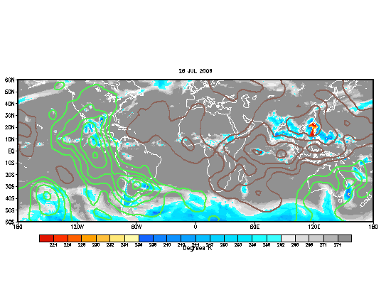
Apparently, I just realized that the velocity potential/upper divergence/MJO map I posted was from July 2006. Weird, but it's only my fault that I did not take a closer look at the datestamp discrepency.

The correct map is here:

The enhacement areas are leaving the Atlantic basin right now at an initial glance, but a new burst as appeared in the eastern Pacific. Given current satellite trends, I suspect that will intensify and move eastward. When that is leaving (maybe in about a 4 days to a week), we could see some marginal quick development. But since the Azores High is in its strongest state right now, and due to strong shearing winds in the GOM, I don't foresee any major development.

Phew! What a flip-flop.

Musings on the Atlantic Hurricane Season

Key issues in this post: possible development in the next week-two weeks; effects of the negative SST anomalies in the eastern Atlantic; hot spots for landfall activity through the remainder of the season.

So far, the Atlantic has been quiet. Not abnormally quiet as it has been in the Pacific (both the west and the east), but quiet, as usually is during this time of year. I expect this to change.

Here are the current velocity potential anomalies:


Green areas indicate enhanced divergence and increased thunderstorm activity. This area of enhancement has actually stalled the past few days, likely due to what I'll explain later in this post. In fact it was about to bipass the Atlantic until TS Dalila in the EPAC, along with a divergence from strong anticyclone in the Four Corners region, reinvigorated the ITCZ in the area. Still, the signal is rather weak, continuing to be hurt by a strong Azores High in the Atlantic, and negative SST anomalies due to the developing La Nina in the EPAC.

The question now is: will the enhanced areas of divergence enter the Atlantic. What I've noticed is that tropical cyclone development usually occurs when the enhancement areas are leaving. The Azores High tends to peak in strength in late July, so it will likely weaken from here on out. In fact, a weak trough is forecasted to amplify near the Azores, which will certainly dent the high pressure cell across the area, temporarily halting the upwelling and the SAL intrusions. When the Azores High weakens, the ITCZ will start moving northward, and perhaps by that time, the areas of enhanced divergence can get settled in the eastern Atlantic.

Don't get me wrong - the CV area doesn't look healthy - it will take time for one month of upwelling to evaporate away, even with strong sun. But that does mean, with the enhancement areas leaving the western Atlantic, we could see some development in the central or western Atlantic in about two weeks. Confidence is low, however. At this point, East coast troughiness says that Texas to Central America are the main threats if something homegrown develops, or it will come close to the east coast or recurve if something develops further east.

This discussion now brings up the second point. As of right now, the Azores High has done a number on upwelling in the eastern Atlantic. This is the first time in a long time that such negative anomalies have appeared in the MDR. Given that the Azores High does weaken like it is forecasted to, the eastern Atlantic may recover in about 2-3 weeks, which indicates possible CV development later in August. But if the Azores High remains strong, and the cold pool remains there, CV storms are not likely going to form. While the current cold pool suggests CV season might start a bit later, it is uncertain what effect, if any, it will have with the number of CV storms. If the Azores High weakens in September, and the CV storms finally come rolling, they will more likely recurve.

Which brings up the third point. Where are the biggest threats for hurricanes this year? La Nina climo argues for stronger Caribbean storms. The East Coast trough will probably remain through much of the year, if so, the East Coast would be under the gun and the Gulf Coast might get a reprieve.

For now, I would say that Mexico, Central America, Hispaniola, and Cuba are under a relatively high threat, and that Texas, Puerto Rico, and the Lesser Antilles have a moderate threat (maybe a lower threat for S. America, ABC Islands and the southernmost Lesser Antilles). All of Florida and the east coast, along with Bermuda, I would say, has a moderate threat, and the Gulf Coast has a low threat. But that's just my prediction.

Wednesday, July 4, 2007

2007 Tornado Season: A Review (FEB-JUN)

The 2007 tornado season was a fantastic one for chasers who went early. Synoptically evident event after event. Although the mesoscale often went awry (you can't predict that stuff from way out), most chasers from March-early May were treated with many good events. But then came the "Death Ridge". There were still events in late May, and June, but they were not as numerous, and often came down to the mesoscale. Of course though, my general rule of thumb is that more things will go wrong with the mesoscale, in a given length of time, than will go right. Although two events pop out in my mind, when nearly everything went right (March 28 and April 21), there were numerous other events which everything went wrong. Nevertheless, the synoptic events are listed below:

Feb. 23-24 (Early season tornadoes in TX, Lower Miss. R. Valley tornadoes)
Feb. 28 - Mar. 1 (Early season EF4 in KS, SE Enterprise, AL Tornado outbreak)
March 28 (High Plains tornado outbreak)
April 13-14 (Mainly bust, few tornadoes in TX and Atl Coastal Plain)
April 21 (TX Panhandle tornado outbreak)
April 23-24 (Plains tornadoes, mainly bust, but Eagle Pass, TX tornado included)
May 4-5 (Greensburg tornadoes, tornado outbreak)
June 6-7 (Mainly bust, few tornadoes in WI)

Chasers also caught tornadoes on March 21, May 22-23, and then June 23 in Canada. But otherwise, that was it. However, March 28, April 21, April 23-24, and May 4-5 were epic days for chasers, with many bagging multiple tornadoes, some wedges (exception of last one with Apr 23-24). For many it was a nice reprieve of the relatively boring years of 2005-2006, although certainly not legendary like 2004, 1991, 1993, 1995, 1999 et al (that I would like to correct from my previous post).

For myself, it was a new beginning. This year was the first which I had even attempted long-range severe wx forecasts. They were quite experimental, and I really did not know what to expect. And I did fairly well. Not bragging, but for my first year at attempting this, I felt like I had grabbed onto something that was right.

My high points:
-Seeing the Feb. 23 event several weeks in advance, though I was a little early with the timing
-Seeing that April would be an active month (that was true b/c the pattern was active, even though due to mesoscale factors, the tornado count was around average)
-Correctly forecasting the early June event and the subsequent arrival of the Death Ridge

My low points:
-Seeing the March 28 outbreak from several weeks out, then rescinding my prediction, only to have it happen
-Thinking early April was going to be extremely active (turns out there was a break from April 3-12)
-Not updating the blog as much as I should've

I guess my overall grade for this year's predictions would be a B+. Long-range, that is. Could've been better w/ more updates, and maybe it was luck that helped me, so an A will never be a grade until I've done this for at least 2 or 3 years.

As it is July already, my focus will now shift toward the tropics. With the tropics, I have yet to do a significant amount of research, but I will try my best.

(P.S. Since this only includes Feb thru Jun, my horrible January forecasts do not count. This is not to vindicate myself; rather, there was not enough tornadic activity in January to justify it as part of the 2007 'tornado season'.)