So far, the Atlantic has been quiet. Not abnormally quiet as it has been in the Pacific (both the west and the east), but quiet, as usually is during this time of year. I expect this to change.
Here are the current velocity potential anomalies:
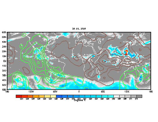
Green areas indicate enhanced divergence and increased thunderstorm activity. This area of enhancement has actually stalled the past few days, likely due to what I'll explain later in this post. In fact it was about to bipass the Atlantic until TS Dalila in the EPAC, along with a divergence from strong anticyclone in the Four Corners region, reinvigorated the ITCZ in the area. Still, the signal is rather weak, continuing to be hurt by a strong Azores High in the Atlantic, and negative SST anomalies due to the developing La Nina in the EPAC.
The question now is: will the enhanced areas of divergence enter the Atlantic. What I've noticed is that tropical cyclone development usually occurs when the enhancement areas are leaving. The Azores High tends to peak in strength in late July, so it will likely weaken from here on out. In fact, a weak trough is forecasted to amplify near the Azores, which will certainly dent the high pressure cell across the area, temporarily halting the upwelling and the SAL intrusions. When the Azores High weakens, the ITCZ will start moving northward, and perhaps by that time, the areas of enhanced divergence can get settled in the eastern Atlantic.
Don't get me wrong - the CV area doesn't look healthy - it will take time for one month of upwelling to evaporate away, even with strong sun. But that does mean, with the enhancement areas leaving the western Atlantic, we could see some development in the central or western Atlantic in about two weeks. Confidence is low, however. At this point, East coast troughiness says that Texas to Central America are the main threats if something homegrown develops, or it will come close to the east coast or recurve if something develops further east.
This discussion now brings up the second point. As of right now, the Azores High has done a number on upwelling in the eastern Atlantic. This is the first time in a long time that such negative anomalies have appeared in the MDR. Given that the Azores High does weaken like it is forecasted to, the eastern Atlantic may recover in about 2-3 weeks, which indicates possible CV development later in August. But if the Azores High remains strong, and the cold pool remains there, CV storms are not likely going to form. While the current cold pool suggests CV season might start a bit later, it is uncertain what effect, if any, it will have with the number of CV storms. If the Azores High weakens in September, and the CV storms finally come rolling, they will more likely recurve.
Which brings up the third point. Where are the biggest threats for hurricanes this year? La Nina climo argues for stronger Caribbean storms. The East Coast trough will probably remain through much of the year, if so, the East Coast would be under the gun and the Gulf Coast might get a reprieve.
For now, I would say that Mexico, Central America, Hispaniola, and Cuba are under a relatively high threat, and that Texas, Puerto Rico, and the Lesser Antilles have a moderate threat (maybe a lower threat for S. America, ABC Islands and the southernmost Lesser Antilles). All of Florida and the east coast, along with Bermuda, I would say, has a moderate threat, and the Gulf Coast has a low threat. But that's just my prediction.
No comments:
Post a Comment